

CARTERVILLE (WSIL) -- It was another nice day across the region. We kicked off the day with plenty of sunshine, but clouds have worked their way back in. Despite more clouds, it was finally warmer with temperatures near average. Temperatures are in the low to mid 70s this afternoon.
The remainder of the evening should be mostly dry. An isolated shower is possible in southeast Missouri but most of the rain will move in after midnight. Temperatures will be quite warm overnight, with lows dipping into the 50s by morning.
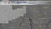
Scattered showers are expected to develop north of a warm front Friday morning. Widespread rain is likely, with the heaviest amounts through the southern half of the area. Amounts will range from 0.25" north to 1.00" south.
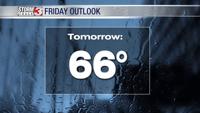
There will likely be some dry time by the afternoon, but a few more storms may redevelop late Friday night.
By the weekend, much warmer and more humid air will move in. This will bring temperatures back into the upper 70s Saturday and low 80s by Sunday. Isolated to scattered storm chances are possible both days, but neither will be a washout.
A very summer-like pattern sets up next week, keeping high temperatures in the low 80s. However, a chance for pop up storms is in the forecast nearly everyday.