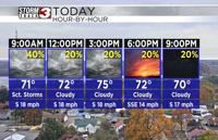


WSIL(Carterville, Ill) -- This morning, showers are entering in our western counties across southern Illinois nad southeastern Missouri. Temperatures are warm, with most locations in the upper 60s and lower 70s, with southerly winds at 15 to 20 miles per hour.
This morning, we will continue to see scattered showers track west to east. The best chances for showers will be across southeastern Missouri, and Western Illinois, maily west of I-57. Areas east of I-57 could see isolated showers, but should remain mostly dry. Areawide, shower chances should become more isolated after lunchtime, and last through the most of the afternoon and evening.
Skies will be mostly cloudy all day, and temperatures should reach the mid to upper 70s for most of us this afternoon. Southerly winds today will also be strong, sustained at 15-20 miles per hour with gusts potentially as high as 35 miles per hour.
Overnight tonight, isolated showers will linger through midnight. But, early tomorrow morning, we will see showers enter into the region in a west to east pattern. As we go through Election Day, we are tracking widespread rain chances as we go through most of the day. A slow moving cold front will push from west to east through the day. It should be out of southern Illinois by 4 to 6 PM, and completely clear the region by 10 or 11PM. Once the cold front clears the area, we will see rain chances decrease, and things should mostly dry out.
Highs tomorrow will be in the low to mid 70s for most of us and sustained at 15-20 miles per hour with gusts potentially as high as 35 miles per hour will last through most of the day until the front passes.
For the middle of the workweek, we should be dry with temperatures that will be in the mid 60s. Rain chances do look to reenter the region later on as we head into the weekend.