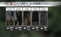


WSIL (Carterville Ill.)--This morning, a lot of us are waking up to temperatures that are in the mid to upper 60s with a few isolated showers. Showers will linger through the morning hours, but we will see the shower chances decrease as we go through the afternoon. Highs today are generally going to be in the upper 70s and lower 80s.
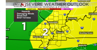
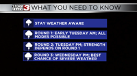
We will be dry during the evening and early overnight hours. However, as we get into the pre-dawn hours tomorrow morning, we will see widespread showers and storms associated with a line of storms that will track from west to east. A few of these could be on the strong to severe side, with the main hazards being damaging winds, small hail, and a brief tornado.
There will be a break in shower and storm activity during the mid morning and early afternoon. However, there could be a few storms that develop in the afternoon. The strength of these storms will be dependent on how much of the instability is used up by the showers and storms in the morning.


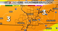
For Tuesday, there is a level 2 risk of severe weather for most of our region. But Tuesday is not our only risk of severe weather. The best chance for severe weather will be Wednesday in the afternoon, and there is already a level 3 risk of severe weather for everyone for storms in the afternoon and evening. All modes of severe weather are possible Wednesday in the afternoon.