CARTERVILLE, Ill. (WSIL) �� A hot day is in store today, followed by the potential for severe storms tomorrow.
This morning we are waking up to partly cloudy conditions with mid to upper 50s and fairly calm winds.
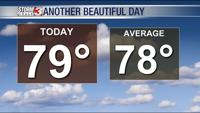
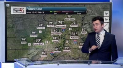
You may need a light jacket to go to work or school but you won’t need it for long as temps will be heating up quickly. Today, you can expect highs in the mid to upper 80s. The clouds will start moving out during midday and the winds will pick up to around 15 - 20 mph. Clouds will move back in by the afternoon hours and will thicken more as we move into the night. Temps won’t decrease by much tonight and will stay in the mid to upper 70s during the overnight hours.
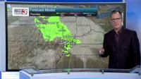
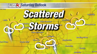
On Tuesday, expect to wake up with warm temps in the mid 70s. Temperatures won’t fluctuate much all day and winds will stay around 10 mph. There’s a chance for scattered thunderstorms in the morning and early afternoon hours. Then another chance for severe storms later on Tuesday night.
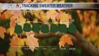
We have a level 2 Slight risk for severe weather on Tuesday. Potential severe storms will be the pattern through Thursday and highs only in the low to mid 70s for the rest of the week.
After Thursday, we should dry out with the potential for a nice weekend.