
- Weather
- Latest Forecast
- Radar
- Weather Cameras
StormTrack 3 Always Tracking
Right Now
- Humidity: 55%
- Cloud Coverage:17%
- Wind: 12 mph
- UV Index: 9 Very High
- Sunrise: 05:44:34 AM
- Sunset: 08:01:28 PM
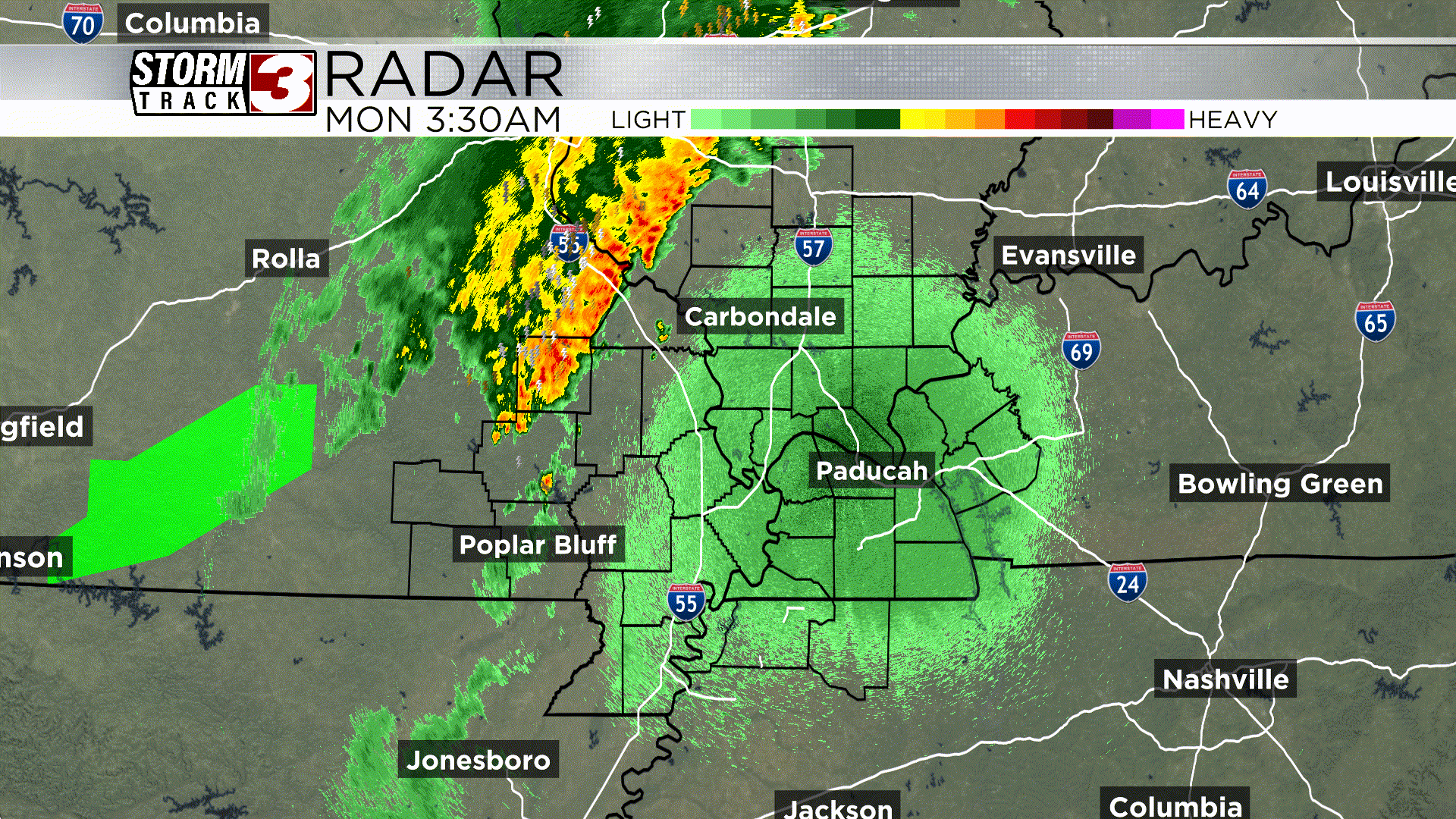
Carterville, IL �� Following a period of severe weather that included a number of reports of tornadoes and other damage across the WSIL viewing area, the threat will gradually diminish through the night. Residents should continue to monitor local conditions, but the most intense activity is expected to move eastward.
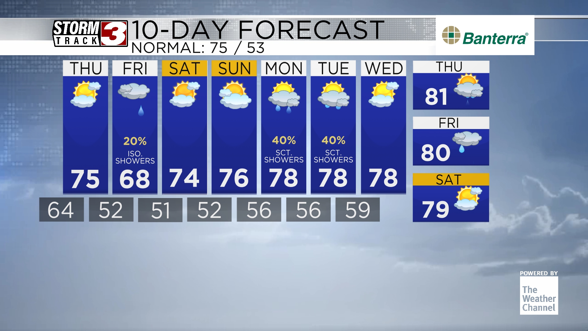
Looking ahead, the forecast for the WSIL area anticipates a return to more typical conditions for this time of year, though some rain chances will linger into next week.
Tonight will be partly cloudy with a continued, but diminishing, chance of a stray severe thunderstorm. The low temperature will be around 62 degrees, with west-southwest winds at 5 to 10 mph.
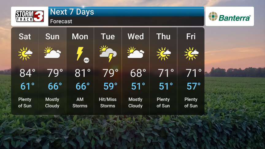
Saturday will bring abundant sunshine with a high reaching a pleasant 83 degrees. Winds will be from the west at 10 to 15 mph. Saturday night will start partly cloudy, giving way to occasional showers later, with a low near 60 degrees and light and variable winds.
Sunday will feature partly cloudy skies in the morning, becoming overcast in the afternoon with a slight chance of a stray shower or thunderstorm. The high will be around 80 degrees with light and variable winds. Sunday night will turn cloudy with thunderstorms developing later, and a low near 65 degrees.
The start of the week will be unsettled with thunderstorms likely in the morning on Monday, followed by a chance of scattered thunderstorms in the afternoon. The high will be around 81 degrees with southeast winds at 5 to 10 mph. Monday night will bring more thunderstorms and a low of 67 degrees.
Tuesday will have variable clouds with scattered thunderstorms and the potential for severe thunderstorms. The high will be 78 degrees with south-southwest winds at 10 to 15 mph. Tuesday night will see scattered thunderstorms in the evening followed by a few showers overnight, with a low of 61 degrees. Wednesday will be partly cloudy in the morning, becoming cloudy in the afternoon with a chance of a stray shower or thunderstorm and a high of 68 degrees.

Hourly Forecast
Carterville, IL
Wind: W @ 12mph
Precip: 0% Chance
Humidity: 55%
Wind Chill: 63°
Heat Index: 64°
UV Index: 1 Low
Visibility: 10 mi
Wind: WNW @ 14mph
Precip: 0% Chance
Humidity: 51%
Wind Chill: 64°
Heat Index: 65°
UV Index: 3 Moderate
Visibility: 10 mi
Wind: WNW @ 15mph
Precip: 0% Chance
Humidity: 49%
Wind Chill: 67°
Heat Index: 67°
UV Index: 5 Moderate
Visibility: 10 mi
Wind: W @ 14mph
Precip: 0% Chance
Humidity: 49%
Wind Chill: 70°
Heat Index: 70°
UV Index: 7 High
Visibility: 10 mi
Wind: W @ 14mph
Precip: 0% Chance
Humidity: 46%
Wind Chill: 72°
Heat Index: 72°
UV Index: 8 Very High
Visibility: 10 mi
Wind: W @ 15mph
Precip: 0% Chance
Humidity: 45%
Wind Chill: 74°
Heat Index: 74°
UV Index: 9 Very High
Visibility: 10 mi
Wind: W @ 15mph
Precip: 0% Chance
Humidity: 44%
Wind Chill: 75°
Heat Index: 75°
UV Index: 8 Very High
Visibility: 10 mi
Wind: W @ 14mph
Precip: 0% Chance
Humidity: 43%
Wind Chill: 76°
Heat Index: 76°
UV Index: 6 High
Visibility: 10 mi
Wind: W @ 13mph
Precip: 0% Chance
Humidity: 42%
Wind Chill: 77°
Heat Index: 77°
UV Index: 4 Moderate
Visibility: 10 mi
Wind: W @ 13mph
Precip: 0% Chance
Humidity: 41%
Wind Chill: 77°
Heat Index: 77°
UV Index: 2 Low
Visibility: 10 mi
Wind: WNW @ 10mph
Precip: 0% Chance
Humidity: 43%
Wind Chill: 77°
Heat Index: 77°
UV Index: 1 Low
Visibility: 10 mi
Wind: WNW @ 7mph
Precip: 1% Chance
Humidity: 45%
Wind Chill: 75°
Heat Index: 75°
UV Index: 0 Low
Visibility: 10 mi
7-Day Forecast
Carterville, IL
Chance of Precip: 0%
Sunrise: 05:44:34 AM
Sunset: 08:01:28 PM
Humidity: 47%
Wind: W @ 15mph
UV Index: 9 Very High
Saturday Night
Partly cloudy. Low 56F. Winds NW at 5 to 10 mph.
Chance of Precip: 15%
Sunrise: 05:43:48 AM
Sunset: 08:02:19 PM
Humidity: 57%
Wind: E @ 5mph
UV Index: 8 Very High
Sunday Night
Partly cloudy skies early. Scattered thunderstorms developing later at night. Low 62F. Winds ESE at 5 to 10 mph. Chance of rain 60%.
Chance of Precip: 59%
Sunrise: 05:43:03 AM
Sunset: 08:03:10 PM
Humidity: 84%
Wind: SE @ 11mph
UV Index: 7 High
Monday Night
Scattered thunderstorms during the evening becoming more widespread overnight. Low 64F. Winds SE at 5 to 10 mph. Chance of rain 80%.
Chance of Precip: 62%
Sunrise: 05:42:19 AM
Sunset: 08:04 PM
Humidity: 82%
Wind: SSW @ 16mph
UV Index: 9 Very High
Tuesday Night
Partly to mostly cloudy skies with scattered thunderstorms before midnight. Low 58F. Winds W at 5 to 10 mph. Chance of rain 40%.
Chance of Precip: 18%
Sunrise: 05:41:38 AM
Sunset: 08:04:49 PM
Humidity: 72%
Wind: WNW @ 16mph
UV Index: 6 High
Wednesday Night
Partly cloudy. Low 48F. Winds NW at 10 to 15 mph.
Chance of Precip: 6%
Sunrise: 05:40:58 AM
Sunset: 08:05:38 PM
Humidity: 60%
Wind: NW @ 14mph
UV Index: 9 Very High
Thursday Night
Partly cloudy. Low 49F. Winds WNW at 5 to 10 mph.
Chance of Precip: 5%
Sunrise: 05:40:19 AM
Sunset: 08:06:26 PM
Humidity: 58%
Wind: W @ 10mph
UV Index: 9 Very High
Friday Night
Partly cloudy in the evening with more clouds for later at night. Low 56F. Winds light and variable.