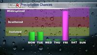


WSIL -- The severe weather threat has ended this morning, but showers will continue through the early morning hours, gradually shifting southeast as much colder air spills in from the north.
By the afternoon, temperatures will be hovering in the lower 40s with strong northwest winds pushing the wind chill into the 30s. There's even a chance for a few snow flurries after sunset this evening, but no measurable snow is expected.

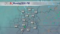
Tonight, temperatures dip into the upper 20s, but readings begin to bounce back into the mid 40s Tuesday afternoon. By Thursday, temperatures will once again be running near 60º.
The next big weather impact looks to arrive Friday. There is still A LOT of uncertainty, but temperatures will plummet and a mix of rain, sleet, and snow is possible.