

WSIL -- For mid-August, the weekend was about as pleasant as it gets! Temperatures will remain below average for much of the week, but rain chances will be increasing.

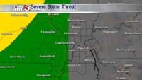
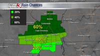
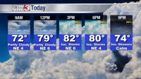
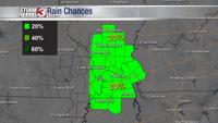
A weak disturbance has a stalled boundary lingering near the Ohio River today. This boundary is separating much of the very humid air in our southern counties, to slightly drier air north. This stalled boundary will also likely focus a few pop up showers and storms during the heat of the day today and tomorrow.

The best chances for pop up storms will be across western Kentucky and southeast Illinois. Farther west, chances for rain will be a bit lower.

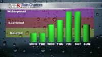
By the middle of the week, a disturbance will move out of the Plains, shifting better rain chances into the region Wednesday, Thursday, and Friday.