

CARTERVILLE (WSIL) �� Wow! Temperatures Tuesday morning dipped back into the upper 40s and lower 50s, finally giving a little taste of fall. Enjoy it, because we’re not quite done with summer-like heat.
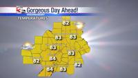
Outside a few high, wispy cirrus clouds, Tuesday will be a mostly sunny afternoon with temperatures running back into the lower 80s. Overall, with the lower humidity, it will be a very comfortable afternoon.
A disturbance moving in from the west will bring the next chance for showers early Wednesday morning. A cold front approaching Wednesday afternoon will likely also bring a few showers and storms and could linger some of the rain chances into Thursday. The cold front will usher in slightly cooler, drier air once again by Thursday afternoon.
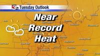
The front will retreat back north as a warm front Friday morning and set the stage for the return of summer. By Friday afternoon, temperatures will zoom back into the upper 80s. A few small chances for rain are expected this weekend, but near-record heat will continue through early next week into the first few days of October.
Meteorologist Nick Hausen has the latest forecast on News 3.