

CARTERVILLE Ill. (WSIL) -- An isolated shower or storm is possible through Wednesday afternoon. Most areas will remain dry. However, if caught in a storm, brief heavy rain and lightning will be the main threats. No severe weather is expected. Any storms should start to diminish after sunset.
We will begin Thursday with more sunshine and warm temperatures. Dry conditions stick around through most of the day. Scattered showers and thunderstorms move in by the afternoon and evening. Those chances linger into Friday. It will not be a washout, there will still be dry time mixed in.
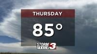
High temperatures Thursday will stay well above average, topping out in the mid to upper 80s. A slight drop in temperatures arrives Friday with highs in the upper 70s.
The extended forecast continues to be warm, accompanied by the off and on storm chances.