


WSIL (Carterville) -- It's a very warm start to the day with temperatures as you're out the door in the upper 40s, low 50s. Skies are clear currently, but clouds will move in by mid morning ahead of the weekend disturbance.
Winds are continuing to be relentless with gusts between 20 to 30 mph out of he southwest. Highs will reach the low 60s by the afternoon.
If you're headed out this evening to enjoy a festive event or to see some lights, you shouldn't have any issues with rainfall. Rain chances will begin to push in overnight and tomorrow morning, but it will likely be fairly isolated.

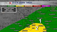
Saturday continues to be the day to keep an eye on. The Storm Prediction Center has highlighted our southeastern most counties under a Slight (2 out of 5) risk. This includes Calloway, Graves, Weakley, Obion, Lake and Pemiscot Counties throughout Kentucky, Tennessee and Missouri.
The highest threats are a brief tornado, strong winds and small hail. All of the threats are fairly low, but they are there so it'll be important to stay weather aware.
Next week trends to be quiet and mild.