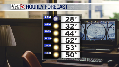


WSIL(Carterville, IL)-- This morning, we are tracking morning lows that are a little warmer than they were yesterday morning. Morning lows are close to average for most of us. We are seeing temperatures in the upper 20s and lower 30s further towards the south. Skies are also mostly clear across the area, and winds are mostly calm.
By 9:00 AM, we are tracking temperatures that will be upper 30s and low 40s. Skies will still be mostly sunny with a southwest wind of about 4 to 5 miles per hour.
By noon we will see temperatures in the lower 50s with sunny skies and west-southwest winds at about 6 miles per hour.
A weak cold front will move through the area early this afternoon. We will not see any rain with this front. However, we could see a few more clouds in the afternoon and evening.
Highs today should be topping out in the low to mid 50s to upper 50s.
This evening, we will see temperatures fall back into the low 40s with winds out of the north at 6 miles per hours. By midnight, we will see temperatures fall into the mid 30s with mostly cloudy skies and a northwest wind of 4 or 5 miles miles per hour.
Tomorrow mornings lows will likely be around 30 degrees with mostly cloudy skies. Cloudy conditions will linger though the early afternoon, before partly cloudy skies move into the area. Highs will be closer to average, with highs in the upper 40s.
Above average highs will return by Thursday, and last through the weekend. Things will also be dry for the next several days.