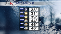


WSIL(Carterville, IL)--This morning, most of us are waking up to temperatures that are close to freezing or at the freezing mark. Winds are also mostly light, so the wind chill this morning should be close to the actual air temperature.
As the morning goes on, temperatures will climb into the upper 30s by mid to late morning, and into the low 40s by lunchtime. Skies will be overcast throughout the morning and winds should be decreasing through out the morning from an east wind of 5 to 6 miles per hour to 2 to 3 miles per hour.
Afternoon highs should be in the mid to upper 40s. Winds should be mostly calm, and skies will likely be mostly cloudy. Despite the cloud cover, we are not tracking any rain showers for the afternoon and evening.
By 6:00 this evening, we are tracking temperatures that will fall back into the upper 30s and into the low 30s by midnight. Winds will also remain mostly calm, and mostly cloudy skies will remain.
In the pre-dawn hours on Sunday, temperatures will likely be close to freezing. Precipitation chances early tomorrow morning will likely remain isolated across the region, and, while current models suggest snow will remain to the north of St. Louis, is possible that some wintery precipitation may mix with rain across northern parts of southern Illinois, mainly between 4:00 and 7:00 AM. If any wintery precipitation does mix with rain, no accumulations are expected, and should have no impact.
By the time more scattered showers enter the region, temperatures will be in the upper 30s and precipitation will fall as all rain for mid-morning Sunday.
We should be done with rain showers by the time we make it to early afternoon. Highs tomorrow will be in the low to mid 40s, and clouds will likely linger through the afternoon and evening.
Behind this system, we are tacking very cold weather to start the work week, with morning lows on Monday and Tuesday being in the low to mid 20s, and highs around 40 for Monday and low 40s for Tuesday. Things will be dry and sunny.
Warmer, more seasonable, weather should be returning by late week.