


WSIL (Carterville) -- A Flood Watch has been issued for all of southern Illinois, southeast Missouri and most of western Kentucky and is in effect until 6 PM.
A Flood Warning has been issued for portions of southern Illinois and is in effect until 5 PM.
A Wind Advisory has been issued for all of southern Illinois, southeast Missouri and western Kentucky and is in effect until 9 PM.

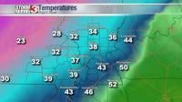
As the remainder of the storms continue to move east out of our area, cold Arctic air has begun to fill in from the north. Temperatures are beginning to dip into the 30s with wind chills in the 20s. Today we saw between 0.10 to 2 inches of rain with lower amounts towards the west.

After sunset, there is a chance for any rain to turn into a wintry mix/freezing drizzle. Puddles and runoff will likely freeze, so take caution if you're driving around tonight or early tomorrow morning.

Temperatures tonight will fall into the teens and clouds are expected to clear by mid-morning. A brisk wind will stick around making it feel colder than it actually is. Highs tomorrow will reach the low 40s but sunshine will return.
This weekend will start chilly but end warmer, with sunshine sticking around on both Saturday and Sunday.