The National Weather Service in Paducah has issued a

* Severe Thunderstorm Warning for...
Williamson County in southern Illinois...
Southeastern Jackson County in southern Illinois...
Southern Franklin County in south central Illinois...

* Until 730 PM CDT.

* At 639 PM CDT, a severe thunderstorm was located near Cedar Lake
Area, or 7 miles southwest of Carbondale, moving east at 55 mph.

HAZARD...60 mph wind gusts and quarter size hail.

SOURCE...Radar indicated.

IMPACT...Hail damage to vehicles is expected. Expect wind damage
to roofs, siding, and trees.

* Locations impacted include...
Carbondale, Marion, Herrin, Murphysboro, Carterville, Johnston
City, De Soto, Crainville, Cambria, Energy, Hurst, Pittsburg, Cedar
Lake Area, Lake Of Egypt Area, Makanda, Freeman Spur, Bush,
Whiteash, Williamson County Regional Airport, and Colp.

This includes Interstate 57 in Illinois between Mile Markers 45 and
62.

PRECAUTIONARY/PREPAREDNESS ACTIONS...

Remain alert for a possible tornado! Tornadoes can develop quickly
from severe thunderstorms. If you spot a tornado go at once into the
basement or small central room in a sturdy structure.

For your protection move to an interior room on the lowest floor of a
building.

A Tornado Watch remains in effect until 800 PM CDT for southern
Illinois. A Tornado Watch also remains in effect until 1000 PM CDT
for south central and southern Illinois.

&&


TORNADO...POSSIBLE;
HAIL THREAT...RADAR INDICATED;
MAX HAIL SIZE...1.00 IN;
WIND THREAT...RADAR INDICATED;
MAX WIND GUST...60 MPH
Weather Alert
...TORNADO EMERGENCY FOR DYKERSBURG AND CARRIER MILLS...

...A TORNADO WARNING REMAINS IN EFFECT UNTIL 700 PM CDT FOR
SOUTHEASTERN WILLIAMSON AND SOUTHERN SALINE COUNTIES...

At 638 PM CDT, a confirmed large and destructive tornado was located
near Carrier Mills, or 9 miles west of Harrisburg, moving east at 55
mph.

TORNADO EMERGENCY for DYKERSBURG AND CARRIER MILLS. This is a
PARTICULARLY DANGEROUS SITUATION. TAKE COVER NOW!

HAZARD...Deadly tornado.

SOURCE...Weather spotters confirmed tornado.

IMPACT...You are in a life-threatening situation. Flying debris may
be deadly to those caught without shelter. Mobile homes
will be destroyed. Considerable damage to homes,
businesses, and vehicles is likely and complete destruction
is possible.

The tornado will be near...
Harrisburg and Carrier Mills around 645 PM CDT.

Other locations impacted by this tornadic thunderstorm include
Stonefort.

PRECAUTIONARY/PREPAREDNESS ACTIONS...

To repeat, a large, extremely dangerous, and potentially deadly
tornado is on the ground. To protect your life, TAKE COVER NOW! Move
to an interior room on the lowest floor of a sturdy building. Avoid
windows. If in a mobile home, a vehicle or outdoors, move to the
closest substantial shelter and protect yourself from flying debris.

&&


TORNADO...OBSERVED;
TORNADO DAMAGE THREAT...CATASTROPHIC;
MAX HAIL SIZE...1.75 IN
Weather Alert
TORNADO WATCH 265 REMAINS VALID UNTIL 10 PM CDT /11 PM EDT/ THIS
EVENING FOR THE FOLLOWING AREAS

IN ILLINOIS THIS WATCH INCLUDES 17 COUNTIES

IN SOUTHEAST ILLINOIS

EDWARDS

IN SOUTHERN ILLINOIS

ALEXANDER             FRANKLIN              GALLATIN
HAMILTON              HARDIN                JEFFERSON
JOHNSON               MASSAC                POPE
PULASKI               SALINE                UNION
WABASH                WAYNE                 WHITE
WILLIAMSON

IN INDIANA THIS WATCH INCLUDES 6 COUNTIES

IN SOUTHWEST INDIANA

POSEY

IN SOUTHWEST INDIANA

GIBSON                PIKE                  SPENCER
VANDERBURGH           WARRICK

IN KENTUCKY THIS WATCH INCLUDES 22 COUNTIES

IN WESTERN KENTUCKY

BALLARD               CALDWELL              CALLOWAY
CARLISLE              CHRISTIAN             CRITTENDEN
DAVIESS               FULTON                GRAVES
HENDERSON             HICKMAN               HOPKINS
LIVINGSTON            LYON                  MARSHALL
MCCRACKEN             MCLEAN                MUHLENBERG
TODD                  TRIGG                 UNION
WEBSTER

IN MISSOURI THIS WATCH INCLUDES 4 COUNTIES

IN SOUTHEAST MISSOURI

MISSISSIPPI           NEW MADRID            SCOTT
STODDARD

THIS INCLUDES THE CITIES OF ALBION, BARDWELL, BENTON, BLOOMFIELD,
BOONVILLE, CADIZ, CAIRO, CALHOUN, CARMI, CHARLESTON, CLINTON,
DIXON, EDDYVILLE, ELIZABETHTOWN, ELKTON, EVANSVILLE, FAIRFIELD,
FORT BRANCH, GOLCONDA, GRAYVILLE, GREENVILLE, HARRISBURG,
HENDERSON, HERRIN, HICKMAN, HOPKINSVILLE, JONESBORO,
MADISONVILLE, MARION, MAYFIELD, MCLEANSBORO, METROPOLIS,
MORGANFIELD, MOUND CITY, MOUNT CARMEL, MOUNT VERNON, MURRAY,
NEW MADRID, OWENSBORO, PADUCAH, PETERSBURG, POSEYVILLE,
PRINCETON, ROCKPORT, SHAWNEETOWN, SIKESTON, SMITHLAND, VIENNA,
WEST FRANKFORT, WEST SALEM, AND WICKLIFFE.
Weather Alert
...A TORNADO WARNING REMAINS IN EFFECT UNTIL 700 PM CDT FOR SOUTHERN
WILLIAMSON COUNTY...

At 620 PM CDT, a confirmed large and extremely dangerous tornado was
located near Lake Of Egypt Area, or 8 miles southwest of Marion,
moving east at 50 mph.

This is a PARTICULARLY DANGEROUS SITUATION. TAKE COVER NOW!

HAZARD...Damaging tornado.

SOURCE...Radar confirmed tornado.

IMPACT...You are in a life-threatening situation. Flying debris may
be deadly to those caught without shelter. Mobile homes
will be destroyed. Considerable damage to homes,
businesses, and vehicles is likely and complete destruction
is possible.

The tornado will be near...
Marion, Creal Springs, and Lake Of Egypt Area around 625 PM CDT.

Other locations impacted by this tornadic thunderstorm include
Spillertown, Williamson County Regional Airport, and Stonefort.

This includes Interstate 57 in Illinois between Mile Markers 46 and
55.

PRECAUTIONARY/PREPAREDNESS ACTIONS...

To repeat, a large, extremely dangerous and potentially deadly
tornado is on the ground. To protect your life, TAKE COVER NOW! Move
to a basement or an interior room on the lowest floor of a sturdy
building. Avoid windows. If you are outdoors, in a mobile home, or in
a vehicle, move to the closest substantial shelter and protect
yourself from flying debris.

&&


TORNADO...OBSERVED;
TORNADO DAMAGE THREAT...CONSIDERABLE;
MAX HAIL SIZE...2.00 IN
Weather Alert
...Dangerous Severe Thunderstorms Moving through the Area this
Evening...

Several intense supercell thunderstorms are occuring across
southeast Missouri, southern Illinois and western Kentucky as of 6
pm. Any of these storms will be capable of producing very large
hail to tennis ball size, wind gusts to 80 mph and a few
tornadoes.

If your area receives a warning this evening, please take them
seriously and be near a sturdy shelter.

The severe weather threat is expected to move out of the area by
midnight.
Weather Alert
The National Weather Service in Paducah has issued a

* Severe Thunderstorm Warning for...
Northern Williamson County in southern Illinois...
Northeastern Jackson County in southern Illinois...
Southern Franklin County in south central Illinois...

* Until 645 PM CDT.

* At 606 PM CDT, a severe thunderstorm was located over De Soto, or
near Carbondale, moving east at 50 mph.

HAZARD...Two inch hail and 60 mph wind gusts.

SOURCE...Radar indicated. Ping pong ball sized hail has also been
reported near Murphysboro.

IMPACT...People and animals outdoors will be injured. Expect hail
damage to roofs, siding, windows, and vehicles. Expect
wind damage to roofs, siding, and trees.

* Locations impacted include...
Carbondale, Marion, Herrin, West Frankfort, Carterville, Johnston
City, Zeigler, De Soto, Crainville, Cambria, Royalton, Energy,
Elkville, Hurst, Pittsburg, Thompsonville, Dowell, Orient,
Hanaford, and Freeman Spur.

This includes Interstate 57 in Illinois between Mile Markers 53 and
69.

PRECAUTIONARY/PREPAREDNESS ACTIONS...

For your protection move to an interior room on the lowest floor of a
building.

A Tornado Watch remains in effect until 700 PM CDT for southern and
south central Illinois. A Tornado Watch also remains in effect until
1000 PM CDT for south central and southern Illinois.

&&


THUNDERSTORM DAMAGE THREAT...CONSIDERABLE;
HAIL THREAT...OBSERVED;
MAX HAIL SIZE...2.00 IN;
WIND THREAT...RADAR INDICATED;
MAX WIND GUST...60 MPH
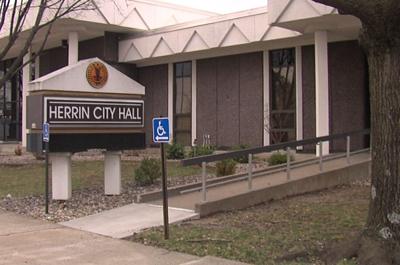
HERRIN, Ill. (WSIL) -- A product on the shelves at gas stations and stores has now been banned in two southern Illinois communities.
Both the City of Marion and City of Herrin banned Kratom during city council meetings on May 12. Both banned the sale and the delivery of Kratom and its derivatives in the cities.
Here is a statement by the City of Marion and a publication with the City of Herrin on the new ordinances.
Download the free WSIL News and Weather apps for the latest stories and alerts sent straight to your mobile device. You may also see us on for the latest videos.