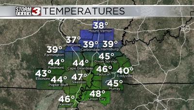


CARTERVILLE Ill. (WSIL) -- Tonight: Clouds stay with us through the evening but should clear out overnight. This will allow our temperatures to drop into the low and mid 20s once again. No precipitation is expected. Winds will remain light and variable.
Monday: Expect temperatures to increase into the 40s for highs. We will also benefit from much more sunshine. This will be a great start to a much warmer week across the area.
January 26th evening forecast with Meteorologist Nick Boynton
Tuesday and beyond: Temperatures continue to warm into the low 50s across the area. With plentiful sunshine in store for Tuesday and Wednesday. Great days to get outside and enjoy the much warmer weather. By Thursday we will see the clouds pick up and the rain chances increase as our next widespread rain maker looks to enter the picture towards the end of the week.