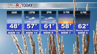


WSIL (Carterville) -- You may have a tough time climbing out of bed today with temperatures dropping into the low 40s. Temperatures will continue to be as cool as this past weekend, but luckily, we should be staying dry.

It may be a good evening to make soup and bake pumpkin cookies because highs will only be in the low 60s. Sunshine should make an appearance today after being gone the last few days.

Into tonight, a high pressure will slide to our south bringing clearer conditions. It could lead to some isolated frost with lows dipping back down into the low 40s and wind chills in the upper 40s. A Frost Advisory will likely not be warranted.
We'll see a steady warm up as we head into the rest of the work week. Highs will be right at average in the low 70s.

A frontal boundary will begin to approach Wednesday, which would push through the region on Thursday. Best chance for scattered showers will return late week. There could be some rumbles of thunder and rainfall totals are only expected to be around a quarter of an inch.