
PADUCAH, Ky. (WSIL) �� A dangerous storm system will soon settle into our region, and with it, strong to severe storms with lots of rain which could lead to catastrophic flooding in areas.
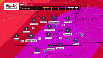
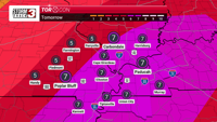
Wednesday: Severe weather is expected to move into our region, bringing with it the potential for large to very large hail, potentially strong tornadoes and widespread damaging winds. Most of our area in southern Illinois, southeast Missouri, western Kentucky and northwest Tennessee has been upgraded to a moderate risk (Level 4 of 5). Throughout our entire viewing area, there is a 15% chance of a significant tornado. The timing of these storms will start in southeast Missouri from 1 p.m. - 4 p.m. and move into southern Illinois and western Kentucky by 4 p.m. - 8 p.m. We have a TORCON level of 7 throughout most of our area on Wednesday.
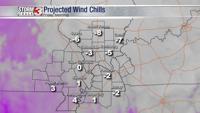
Peak wind gusts could be up to 45 mph or more. Sustained winds are expected to be 25 mph - 35 mph. Be prepared for problematic driving conditions.
There is also a flood watch for our entire coverage area, with the exception of Madison County, Missouri and Randolph County, Illinois.
There is widespread and dangerous flooding expected with this stalled system, with the potential of 10-15 inches of accumulated rainfall at any given place in our area starting on Wednesday through Saturday night. Flash flooding concerns will be ongoing starting on Wednesday through Saturday night with more concern on Saturday as flash flooding could be potentially catastrophic.
Excessive rainfall outlook is high (level 4 of 4).