

CARTERVILLE (WSIL) -- It has been a pretty nice end to the week. Despite the cloud cover, temperatures have climbed into the 60s and 70s. An isolated shower or sprinkle will be possible through about 10 PM, before moving out.
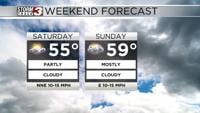
Saturday will bring big changes. Temperatures will drop back below average, dipping into the mid 50s for highs. Gusty winds out of the north northeast will make it feel even cooler. Wind gusts will be between 20 and 25 mph at times.
Sunday more clouds are expected but temperatures will warm slightly. Highs will climb back up near 60s degrees. It will continue to be breezy with winds out of the east gusting near 20 mph.
Dry conditions are expected through the weekend. Our next chance for widespread rainfall will arrive Monday evening and continue into Tuesday. Severe weather is not anticipated at this time, just a soaking rain and a few rumbles of thunder.