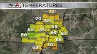


Carterville Ill. (WSIL) -- Rain is slowly moving out of the region from north to south through this evening. Everyone should be dry by about 7-8PM this evening. Temperatures today have been quite below average with many of us staying in the mid 60s for high temperatures due to the clouds and rain. Also, with the front moving completely through the area a northerly wind will take over bringing cooler and drier conditions as well. Expect temperatures to remain below average but in the 70s for the next couple days since the sun will be out.

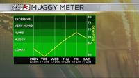
We will have plenty of dry time over the next week or so with very little in the way of rainfall moving into the region for the foreseeable future. Even better is how it will feel outside for at least the first half of the week. We will have northerly winds and a much drier air mass in place. That will allow low temperatures through Wednesday to be in the 50s and quite chilly for some and highs in the 70s. Humidity a non factor and in the comfortable ranges for Monday through Wednesday.
After that though we quickly switch things up with temperatures getting much warmer after Wednesday with our temperatures consistently getting into the 90s for high temperatures and of course the humidity returning with them. Luckily, we still remain dry through next weekend.