

WSIL(Carterville, Ill.) -- This morning, we are tracking temperatures that are on the warm side, in the mid to upper 40s for most of us. However, some locations across southeastern Missouri and western Illinois are in the lower 40s and upper 30s.聽
Morning Forecast December 30th, 2024
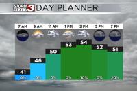
Today you can expect to see temperatures in the lower 50s by lunchtime, and highs that will be in the mid to upper 50s. Skies will be overcast through most of the day today, and winds will be mostly calm. But, things will change as we get into the evening. Isolated showers are possible after 6PM and they will grow more scattered after midnight.聽 No thunderstorms are expected, but scattered showers are expected to continue through the pre-dawn hours.聽
These showers are associated with our next cold front. This front is expected to push through between midnight and 7AM tomorrow morning, and once the front clears the region, shower chances should turn more isolated. The biggest impact that we will see behind this cold front is a major drop in temperatures. Tomorrow's high will arrive between midnight and 1Am tomorrow, in the mid 50s. By 7AM tomorrow, temperatures will be in the low to mid 40s, and linger in the low 40s and upper 30s through most of the afternoon.聽
Winds tomorrow are expected to be on the strong side tomorrow, with sustained winds at 15 to 25 miles per hour, potentially gusting to 35 miles per hour in the late morning hours.聽
Once the cold weather arrives, it will be here to stay. High temperatures on Wednesday will only top out into the mid 30s. The lower 40s are possible for Thursday and Friday, but another system will bring temperatures that may not get above freezing or the weekend and early next week.聽