CARTERVILLE (WSIL) �� A much warmer start to Thursday morning with temperatures in the upper 50s and lower 60s. The warm up is courtesy of an increase in clouds overnight and a south wind kicking in.
There’s a couple chances for isolated showers throughout the day Thursday, but for the most part, it will be a warm, cloudy, and breezy day. South winds may gust up to around 20 miles per hour.
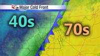
After midnight, rain chances will increase as the strong cold front begins to approach from the west. Severe storms are not anticipated at this time, but a few rumbles of thunder along with downpours are possible.
Friday is the big day of change we’ve been chatting about all week long.
FRIDAY MORNING: Showers, a few rumbles of thunder. Temperatures in the upper 60s and lower 70s.
Cold front will arrive from the north and west by mid-morning and sweep south and east through the early afternoon.
FRIDAY MIDDAY: Temperatures will be falling behind the front quickly. Expect an initial 15 degree drop back into the lower 50s through the early afternoon.
FRIDAY AFTERNOON: Strong northwest winds will keep temperatures falling, likely back into the 40s by mid-afternoon. Lingering showers behind the front will make for a somewhat unpleasant end to the day.
FRIDAY NIGHT: Temperatures fall back into the lower 40s with strong northwest pushing wind chills back into the mid to upper 30s. Light rain showers begin to exit through early evening.
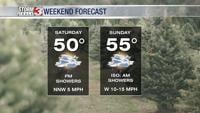
SATURDAY MORNING: Brrrr! Temperatures in the upper 30s are expected in southern Illinois and southeast Missouri with lower 30s in western Kentucky. Frost development still appears unlikely at this time due to a breeze expected.
SATURDAY AFTERNOON: Sunshine returns, but temperatures likely don’t make it above 60 degrees. A chilly mid-October day.
Meteorologist Nick Hausen is tracking this strong cold front along with a second front next week. He has the latest on News 3.