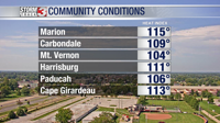


WSIL(Carterville, IL)-- It's safe to say our heat wave is here. This afternoon, the air temperature reached the mid to upper 90s for most places across the region. But, when the humidity is accounted for, the heat index reached 115 in Marion, 111 in Harrisburg, 113 in Cape Girardeau, and 106 in Paducah.

We do have an excessive heat warning in effect this afternoon through Thursday, because these hot temperatures are here to stay. For the rest of the evening, temperatures will remain in the 90s likely through the 7:00 hour tonight. We will not be cooling off as much overnight tonight with lows to start tomorrow likely being in the mid to upper 70s.

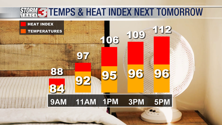
Tomorrow, we are tracking temperatures to be into the upper 90s by early afternoon and lasting through the evening. The heat index tomorrow will likely top 110 tomorrow afternoon again.

Tuesday, Wednesday, and Thursday look to be our hottest days this week with temperatures all three days getting close to the 100 degree mark. Additionally, the humidity will be very high all three days, which means the heat index will likely be around the 110-115 degree mark all three days.
Looking more long term, things should begin to return to more normal temperatures by Saturday and Sunday with highs in the mid 80s. There is also an isolated chance of a shower or thunderstorm on Friday afternoon.