

WSIL(Carterville, IL)-- This morning, we are tracking temperatures in the mid to upper 30s, with wind chill values in the lower 30s and upper 20s.
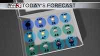
Today, conditions will be mild with temperatures in the upper 40s through the mid morning hours. Skies will be sunny this morning with a southwest wind of of 5 to 7 miles per hour.
Highs today will be in the upper 40s to near 50 across southern Illinois, and we could see the low 50s further towards the south around southeastern Missouri and western Kentucky. Cloud cover will be increasing through the afternoon. Winds will also shift out of the southeast at 10 to 15 miles per hour.
This evening, we are tracking temperatures that will be in the low 40s with mostly cloudy skies. There is a chance of isolated showers this evening.
Tomorrow, we are tracking a very active day weather-wise. We will see widespread showers and thunderstorms tomorrow morning. A few storms could be on the strong to severe, but widespread severe weather is not expected.
The heaviest of rain will likely fall in the early morning hours. However, scattered showers are likely through the day. Many locations could see an inch to and inch and a half of rain, with up to two inches of rain possible in isolated spots.
Highs in the low 50s tomorrow will come in late morning to lunchtime hour. However, by 3:00 PM, we will see temperatures in the upper 20s. We will likely experience a transition from rain over to sleet and snow in the afternoon hours. However, no substantial accumulations are expected. Only a light dusting is possible on grassy surfaces in our northern most counties.
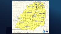
We are also tracking very strong winds with this system, which will be sustained at 20 to 30 miles per our with gusts up to 50. For this reason, there is a winds advisory in effect from 6:00 AM tomorrow morning through midnight Saturday.
Behind this system, we are tracking very cold temperatures that will be in the 20s and teens for highs Saturday and Sunday.