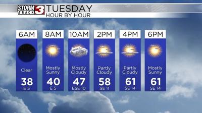


WSIL(Carterville, Ill.) -- This morning, we are tracking mostly clear skies, with temperatures in the mid to upper 30s across most of the area, with variable winds at 5 to 10 miles per hour. So, as your headed out the door, you will want to grab a light jacket!
For today, we are tracking skies that will be partly cloudy to mostly sunny. Temperatures today will reach the upper 40s by the midday hours and then into the upper 50s to lower to mid 60s for highs. Steadily, we will see sustained winds increase, out of the southeast at 10 to 15 miles per hour.
This evening, we will see clouds push in out ahead of our next system, which is expected to impact us tomorrow. Temperatures tomorrow will be warm, likely reaching the mid to upper 70s, with winds that will be out of the south at 20 to 25 miles per hour, with gusts that will be running as high as 40 to 35 miles per hour.
Wednesday will certainly be a day to watch for the potential of severe. The entire region is in an enhanced risk for severe weather, with all hazards possible, including the potential for large hail, damaging wind, and tornadoes, some of which could be on the stronger side. The window for severe weather, for the entire region, should be between 1PM and 10PM. Again, this a broad window, and will change as more details come out.
Perhaps more concerningly, we are tracking the potential for significant rainfall and subsequent flash flooding between Wednesday and Sunday. This is due to a frontal boundary that will stall out, and give us lots of widespread rain. rainfall totals for southern Illinois cupid be between 4 and 8 inches, with locally higher totals as high as 10 to 12 inches.