

WSIL -- Feeling summer-like this morning with warm, humid air in place. Temperatures to start are in the upper 60s and lower 70s and with sunshine will quickly rise into the 80s.
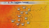
This afternoon, temperatures are likely to peak in the upper 80s in southern Illinois and western Kentucky with a few spots creeping into the lower 90s in the Missouri Bootheel.

Dew points will likely be highest across southeast Missouri and southwest Illinois where the heat index will approach 95º.
A slight change in the pattern could bring a spot shower or two first thing Wednesday morning, but the overall rain chance remains very low through the end of the week.
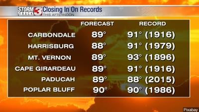
Wednesday afternoon will be the hottest of the week with highs in the lower 90s and the heat index at least into the mid-90s. The record Wednesday in Carbondale is 89º and it may fall.

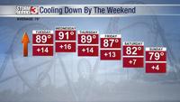
Hot weather sticks around through Thursday, but the pattern will shift by the weekend, ushering in slightly cooler air and a better chance for a few scattered storms.