


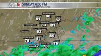


CARTERVILLE, Ill. -- The storms yesterday did not drop as much rain as expected. Now that the cold front has passed towards the south, clearing conditions are expected throughout the day.

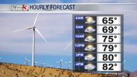
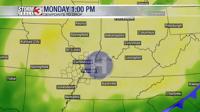
Early this morning through the early afternoon, an isolated shower or thunderstorm can be expected. Areas to the north of the Ohio River will have a lesser chance of seeing isolated showers and thunderstorms, and areas to the south will have a greater chance. Any storm that does develop today will likely be short lived and brief. Additionally, these thunderstorms will remain well below severe limits, and widespread rainfall is not expected today. Highs today will be in the low 80s for much of the region, but where we do see those isolated showers, temperatures may be a little cooler.

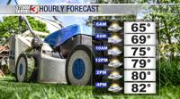
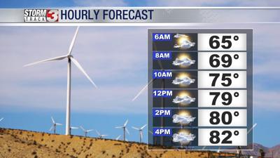
The storm chances will diminish through out the day as a high pressure system moves into place later today. This will take our dew points from the upper 60s and low 70s yesterday, to a more comfortable level in the mid to upper 50s by tonight. These lower dew points will cause temperatures to cool tonight into the low to mid 60s across the region.

Tomorrow will be pleasant as well with temperatures in the mid to upper 80s and abundant sunshine.
As we look ahead to next week, we are tracking pleasant weather to continue on Tuesday. We are also tracking our next chance of showers and storms on Wednesday and Thursday.