

CARTERVILLE (WSIL) -- We saw quite a bit of sunshine today, with mild temperatures. Temperatures have climbed back into the 50s this afternoon. Hopefully you enjoyed the blue skies, high clouds have started to move back into the region.
Clouds will thicken through the overnight hours, as our next system approaches. This will help temperatures stay warmer tonight, so frost will not be a concern. Lows will only dip into the upper 30s and low 40s by Thursday morning.
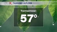
A cold front will begin to move in Thursday, this will be a chance for a few isolated showers throughout the morning. However, widespread rain is more likely through the afternoon and evening. Severe weather is not expected, but a few rumbles of thunder are possible.
It will also be very windy ahead of this system. Winds will pick up out of the south, with gusts near 40 mph. High temperatures will be seasonable, topping out in the upper 50s.
The showers will linger into early Friday morning, until the front moves east. Overall, rainfall totals aren't a big concern. On average 0.5"-1.0" is expected. Much of the day Friday will end up being dry but cool. Highs will dip back into the 40s.
The front reinforces our cold air, bringing back lows in the 20s and highs in the low 40s by the weekend.