


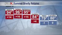


WSIL (Carterville) -- The temperatures are continuing to crank up as highs today will reach 90. A few more clouds have rolled in but plenty of blue skies are still peeking through. Dew points have climbed into an uncomfortable level, making it feel very humid outside.

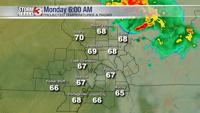
The first half of overnight should remain quiet, with lows staying warm in the upper 60s, but some of us may start tomorrow with some isolated showers. Nothing major is expected out of this. Our far northeast counties like Hamilton County, could possibly see rain before noon.

Even with the isolated shower chance, it won't stop the heat. Tomorrow will be even warmer than today with highs in the mid 90s. We'll be nearing in on some record breaking heat through Wednesday.

Humidity will also be high, causing heat indices to soar close to triple digits.

A pretty strong front is expected to move through in the second half of the week, bringing highs back down to average for this time of the year just in time for fall.