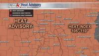


WSIL (Carterville) -- Another brutally hot day across our area, and much of the country. Highs today will top out in the upper 90s, possibly triple digits, with heat indices above 100.

Not much relief tonight, dipping only into the mid to upper 70s. Skies will remain clear and dry for a bit longer as well.

Tomorrow, as far as temperature, will be similar to today. Heat indices again in the triple digits. Biggest change is the chance of storms to end the day.

The Storm Prediction Center has parts of the region under a marginal (1 out of 5) threat for severe weather and a small portion of southern Illinois over Mount Vernon under a slight risk. Biggest threat to watch for is localized flooding, along with strong wind gusts that could knock down trees and powerlines.

Tomorrow won't be the only chance of rain we'll see this week as most of the days have at least an isolated chance. Good news is, we'll 'cool off' a bit.