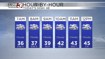


WSIL(Carterville, IL)-- This morning, some of us are waking up to a mix of rain, sleet, and snow across southern Illinois. Rain is falling further towards the south where temperatures are a little warmer. No accumulation is expected.
For today, you can expect showers to end by mid morning, with temperatures that will be in the upper 30s and lower 40s. Even though the showers will exit the area, we will still see cloud cover linger through the day.
Highs this afternoon will be in the upper 40s. Winds will be out of the south at 5 to 7 miles per hour this afternoon, before calming through the evening and overnight hours.
Tonight, we will see clearing skies, and skies tomorrow morning will be partly cloudy before skies turn mostly sunny. Morning lows tomorrow will be in the mid 30s. Highs will be in the low to mid 60s tomorrow and winds will be out of the south at 5 to 7 miles per hour.
Sunday will be even warmer, with highs expected to be in the low to mid 70s with partly cloudy skies. Winds will increase and be out of the south at 15 to 20 miles per hour with higher gusts possible.
We are keeping an eye on increasing rain and storm chances for the start of the work week.