


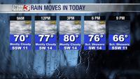


WSIL (Carterville) -- Yesterday was a warm start to the day but today will top it with temperatures in the 60s and 70s as you're headed out the door. You won't need to dress warm, but a rain jacket will come in very handy. Few isolated showers are moving through the first half of today.

This afternoon and evening will be very warm with highs in the low 80s. Rain chances will increase as we head into the evening and we may even see a few thunderstorms. Luckily not anticipating anything severe.
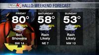
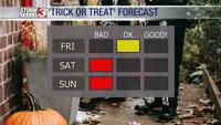
If you have plans tonight I would hold off on rescheduling but it's a different story for this weekend.

A cold front will push through late tonight and will continue our chances of rain into Hallo-Weekend. The greatest chances will come in the second half of the day with widespread rain expected. It could also be pretty heavy at times, as we could pick up a few inches.

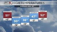
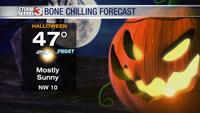
Behind the front and closer to the actual holiday, temperatures will be bone-chillingly cold as we welcome back 20s and 30s. The cool air pours in and will likely result in 3 nights of subfreezing temperatures, bringing an end to growing season.