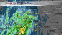


WSIL (Carterville) -- Despite forecasting isolated and stray showers overnight, it instead turned into a good, soaking rain. Some areas like the bootheel, have picked up a few inches of rain.

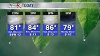
Temperatures this morning are very mild in the low 70s. By this afternoon highs and heat indices will be very similar to yesterday. Temperatures climbing into the mid 80s but feeling more like the mid 90s thanks to the extra humidity.
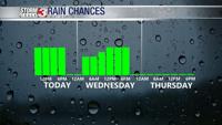
We're seeing a bit of a lull in showers at the moment, but they'll pick right back up right before lunchtime and stick around through the evening.

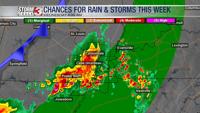
The good news is the chance of severe weather is becoming slimmer. While a warning is possible, it's unlikely. Tomorrow is still trending to produce storms.

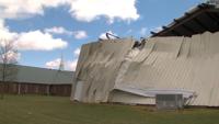
Make sure to stay weather aware tonight and into tomorrow morning. Before the passage of a cold front, a few strong to severe storms may be possible. Biggest threats continue to be damaging winds and hail.

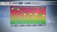
Behind the front we have 'fall-like' weather expected. Highs stay in the 80s but humidity drops making conditions feel much nicer.