


WSIL (Carterville) -- We're waking up to warm conditions again today. Cloud cover stuck around last night, trapping the heat we received yesterday. Thanks to a blocking pattern, we've been seeing summer-like conditions for the last few weeks and to kick off fall.

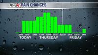
A strong cold front is digging through the center of the country and is currently pushing east towards us. Ahead of the front there's a few scattered showers and storms that will possibly dampen our evening. Despite the chance for storms, we aren't expecting anything severe.

Rain chances stick around off and on overnight. We see conditions turn more widespread into Thursday with a washout expected for almost everyone. Highs tomorrow will be roughly 10 degrees cooler with the mid 70s.

We'll need to be weather aware again this weekend but not for storms, but the potential for the first frost of the fall. Temperatures could fall into the upper 30s.