

CARTERVILLE (WSIL) ��
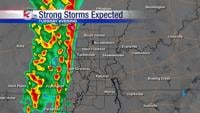
TUESDAY MORNING STORM UPDATE �� A line of storms is expected to move into the region this evening and bring a risk for damaging winds and possibly a few brief spin-up tornadoes.
WHERE: The biggest risk for severe storms is in southeast Missouri and points west of I-57 in southern Illinois. The threat diminishes rapidly across southeast Illinois.
WHEN: Storms will likely arrive into southeast Missouri close to sunset and then gradually shift eastward through the evening.
MAIN THREATS:
Damaging Winds
Brief Tornadoes
Localized Street Flooding
Summary: In the wake of showers and storms this morning, an outflow boundary pushed into northeast Arkansas and northwest Tennessee. Behind the outflow temperatures have dropped back into the 50s across much of southern Illinois and southeast Missouri. That outflow boundary has since started to retreat back to the north as a surge of warm, humid air is set to settle back into the region this afternoon, likely resulting in temperatures in the 70s and low 80s. A line of storms that has a history of producing strong winds and even a few tornadoes continues to inch eastward out of Oklahoma into southwest Missouri and northwest Arkansas. With a destabilizing atmosphere over southern Missouri and northern Arkansas, storms are expected to intensify this afternoon as it approaches our region.