

CARTERVILLE (WSIL) -- It has been a very foggy and warm day so far. Temperatures for south of the rivers have climbed into the upper 60s and low 70s this afternoon. While most of the day has been quiet, that will quickly change.

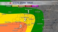
A few storms have already started moving into the bootheel of southeast Missouri. The threat for storms and severe weather will increase throughout the evening and overnight. There will be two rounds. The first will continue moving in from the southwest around 5PM. Damaging winds, heavy rain and lightning are expected.
Round two will be the wave to watch out for. Unfortunately, this is timed to move through after midnight. It is very important that you have multiple ways to get alerts, something that will wake you up. Far southern Illinois, southeastern Missouri and western Kentucky need to stay weather aware. Damaging winds and an isolated tornado or two are possible.

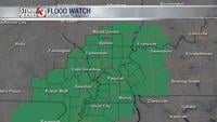
Heavy rain will also lead to flooding issues. Flooding is very difficult to see at night. Remember, turn around and don't drown. A Flood Watch has been issued for the entire viewing area until 9 AM Tuesday, 2"-5" is possible.
Stay safe and weather aware. The Storm Track 3 Team will keep you updated with the latest information.