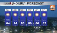


WSIL(Carterville, Ill.)-- This morning, most of us are waking up to temperatures in the lower 60s and a few spots have fallen into the upper 50s in Marion and Mount Vernon, Illinois. Skies this morning are mostly clear, and they will remain mostly sunny all day.
Sunny skies will help us warm up as we go through the day today. We will be in the upper 60s by 9AM, and we will see temperatures in the lowe 80s by the midday hours. Highs today will be in the mid to upper 80s area wide. Dew points today will be in the lower 50s, so it will feel less humid than the last few days.
Despite the fact that wids should remain mostly calm, there is still an elevated fire risk thanks to warm highs, and dry conditions.
Clear skies are expected overnight, and morning low tomorrow will be in the lower 60s and upper 50s once again. Sunny skies are expected all day tomorrow, and highs will be in the mid to upper 80s once again. Dew points will be in the lower 50s, so the elevated fire potential will remain.
Highs through the end of the workweek and weekend will be in the mid to upper 80s and even the lower 90s. This is thanks to an area of high pressure that will remain over the region. This area of high pressure will also heel us say dry, with only isolated shower and storm chances expected late Friday and early Saturday.
Better shower chances should arrive next week.