


WSIL (Carterville) -- Today has been deceiving thanks to the sunshine and chilly temperatures. We're about to hit our high in the mid 30s today, barely staying above freezing. Into tonight, temperatures will dip into the mid 20s with a wind chill a few degrees lower. Skies will remain clear.

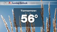
Tomorrow will be much warmer as highs climb into the upper 50s, low 60s for some, with the sunshine still sticking around. It will be windy so prepare for gusts close to 29 mph. Sunday's lows will be in the lower 40s as winds pickup over night.
Monday during the day will remain pleasant but windy, with highs in the low 60s and mostly sunny conditions. The first system we're tracking will begin overnight Monday into Tuesday morning, bringing the potential for heavy rain. We'll get a brief break before our next precipitation chance.