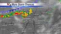


WSIL(Carterville)-- This morning, we are seeing showers and a few thunderstorms exit the region to the south. There is no longer any chance for severe weather. We are waking up to warmer temperatures once again in the upper 50s. and lower 60s. However, we will see temperatures drop gradually as we go through out the day.
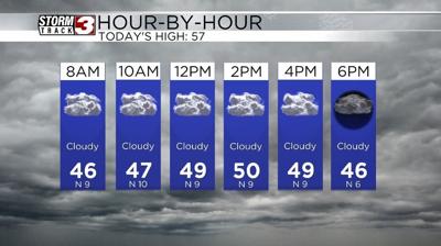
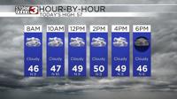
Today, you can expect to see a few isolated showers lingering this morning, mainly in our southern and eastern most counties. We will likely remain dry through mid morning before the chance of light scattered showers move back into the area this afternoon. Temperatures will be at their warmest this morning, before cooling though the day. By 10:00 am, temperatures should be in the mid to upper 40s.
Skies today will be mostly cloudy to overcast, and winds will be out of the north and 10-12 miles per hour this morning before gradually decreasing through the morning hours, and should be out of the north by mid afternoon at 5-6.
Temperatures tomorrow will once again start in low to mid 30s to start the day and skies will be mostly cloudy before becoming overcast. Highs tomorrow will be in the lower 50s. We will have ample dry time tomorrow morning before a few isolated showers work their way into the bootheel and southern Kentucky.
For the start of the work week, we are tracking temperatures for Monday that will be in the lower 30s before dropping into the mid to low 30s for the afternoon. There is a chance that we could see rain transition over to snow in the afternoon, but no significant accumulation is expected.
Whatever does fall will quickly melt off as highs will be returning to the mid to upper 50s by midweek.