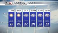


WSIL(Carterville, IL)--Overall, this morning we are tracking mostly cloudy skies and dry conditions. Temperatures as you are waking up are in the 20s, and wind chill values that are in the teens and low 20s. So overall, it is not nearly as cold as it has been over the last few mornings.
Overall today, skies that will be mostly cloudy this morning and will remain mostly cloudy through the afternoon. However, we could see a few breaks in the clouds late morning into early the early afternoon. We do have a very good chance of breaking the freezing mark today with highs that will be in the mid 30s.
We also are tracking some wintry precipitation that will move through parts of the area today. We should see a few flurries and snow showers across the region this morning. No significant accumulations are expected with the morning snow showers.
There will be a brief break in the activity before a we see a wintry mix develop across western Kentucky and far southeastern Illinois. This will be a mix of freezing rain, sleet, and snow. No significant accumulations are expected. However a glaze of ice is possible, which is certainly enough to cause issues on roadways.
For this reason, there is a Winter Weather Advisory in effect for all of western Kentucky from 10:00 AM this morning through 9:00 AM tomorrow morning.
We could see a few flurries this evening, but again, no significant accumulations are expected.
Cold artic air will return for tomorrow with afternoon temperatures in the teens. Highs on Saturday will also be in the teens, before temperatures warm significantly next week. We will also see plenty of chances for rain next week.