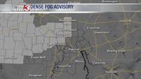


WSIL -- A Dense Fog Advisory is in effect this morning for areas of southwest Illinois and much of southeast Missouri until 9 a.m.

A stalled boundary has been sitting across western Kentucky since Tuesday evening.

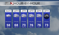
The front will gradually move south this morning, shifting rain south into Arkansas and west Tennessee. Despite a dry Wednesday, low clouds will continue to stick around, keep temperatures only in the low to mid 50s.

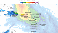
After midnight, a storm system will track in from the west. This will send widespread rain into the region Thursday. It will be the wettest day of the week with 0.5-1.0" of rain expected areawide.
By Friday, the system exits, bringing another dry, but cloudy day. Yet another disturbance will bring more showers to start the weekend.