


WSIL -- Warm & humid to start the morning with temperatures in the upper 60s and lower 70s.

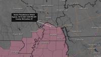
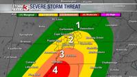
There are quite a few showers & storms near the St. Louis area early this morning with a notable outflow boundary tracking southeast. The expectation is for that outflow to move into the northwest edge of our viewing area by mid-morning with a scattered showers and storms.
As the warm, humid air takes over, the outflow will likely stall. This will be the focus for more storm development during the mid to late afternoon. A few storms could be strong with small hail and gusty winds.

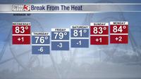
By Thursday morning, the cold front will be cutting across the region. A few showers are possible along this boundary, but as it shifts south, so will the rain chances.

Behind the front, cooler, less humid air will filter in from the north and west.