
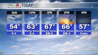


WSIL -- While you'll likely still need a jacket or sweatshirt, it is much warmer this morning with temperatures in the low to mid 40s.

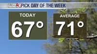
Clouds have moved in from the west and will be around this morning, but they should clear by this afternoon. Sunshine and a light breeze from the south will make for one of the nicest days this week to be outside, high temperatures will climb to the upper 60s.
There is a small chance for a few showers Wednesday, mainly in the Missouri Bootheel and northwest Tennessee. Temperatures will remain in the mid 60s through Wednesday.
A southern track disturbance will bring a pretty good chance for showers locally on Thursday, especially during the afternoon and evening.
While a few showers may linger into Friday morning, but Friday will be a break between systems.
Another storm system will track into the Midwest this weekend, likely leading to scattered showers on Saturday and a few isolated showers on Sunday.

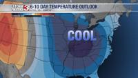
The 6-10 day outlook continues to keep cooler than average temperatures in the area into the first part of May.