


WSIL -- What a weather week! Sunshine and very warm temperatures will continue for at least a few more days.

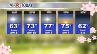
While the mornings are a little cooler with temperatures in the mid to upper 40s, the afternoons are full of sunshine and temperatures in the mid to upper 70s.
Relative humidity will drop below 30% again this afternoon, leading to a slightly elevated field fire threat.

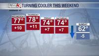
The beautiful weather will continue for most through Friday. There is a small chance for a stray shower Friday, but most of the rain chances hold off until Saturday.

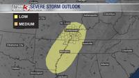
As a cold front approaches the region, showers and storms will increase Saturday afternoon and evening. The wind shear is rather limited, but there is some instability, so an isolated strong storm or two is possible.
In the wake of the cold front, Sunday will be dry, but much cooler and breezy. High temperatures will only be in the lower 60s Sunday and Monday.