


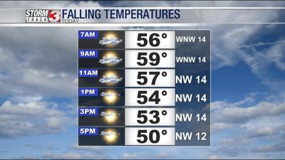
WSIL -- A cold front will sweep across the region Thursday. Temperatures will quickly climb into the upper 50s and lower 60s this morning, but as the front moves through, temperatures will begin to drop this afternoon. South winds to start the day will also shift to the northwest and become breezy with gusts up to 25 miles per hour possible.

Temperatures will finally bottom out Friday morning in the upper 20s. North winds will keep temperatures down Friday afternoon with highs only in the mid 40s.
This weekend, temperatures quickly bounce back up, rebounding to the upper 50s by Sunday afternoon.

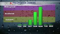
A few weak disturbances will bring a chance for a few isolated showers Saturday morning, primarily focused in the Missouri Bootheel and northwest Tennessee.
Another disturbance will bring more rain Sunday, resulting in at least scattered showers during the day.
Then, another big storm system Monday will bring widespread rain and potentially a few rumbles of thunder.
The long range outlook continues show temperatures remaining well above average to wrap up the month of February and into the first part of March.