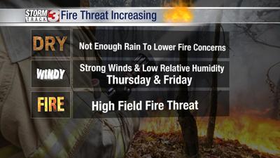


WSIL -- A Red Flag Warning is in effect Thursday afternoon. Relative humidity will drop below 30% during the afternoon and the wind will gust over 25 miles per hour from the west/northwest, resulting in a high fire threat. Burning, including prescribed and controlled burns, is not recommended.
A lot of sunshine is expected this afternoon, but temperatures will be fairly cool, with highs in the mid to upper 60s.
The fire danger will continue into Friday afternoon.
The next chance of rain will come with another cold front Saturday afternoon. An isolated strong storm or two can't entirely be ruled out in primarily the Missouri Bootheel and western Kentucky.
Very cold air will plunge south early next week with freezing temperatures likely Monday night.