
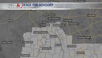


WSIL -- A Dense Fog Advisory has been issued for parts of far southern Illinois, western Kentucky, and southeast Missouri. Fog could reduce visibility in some locations to less than a quarter of a mile.

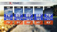
It will be a hot and humid afternoon to wrap up the week with temperatures pushing into the upper 80s, but the humidity will make it feel considerably warmer with heat indices pushing into the mid to upper 90s.

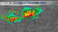
The next chance for storms arrives late tonight and into the early morning hours Saturday. A complex of storms is expected to track in from the northwest, generally after midnight. Storms could be strong with heavy rain and a lot of lightning. A few storms may also produce hail and isolated damaging winds.

By mid-morning, rain will be exiting to the southeast. Sunshine and very humid conditions will return by the afternoon with temperatures in the upper 80s and heat indices into the upper 90s.
The next good chance for storms will arrive late Sunday night into Monday morning as a significant cold front tracks south. In the front's wake, temperatures will drop back into the lower 80s for much of next week.