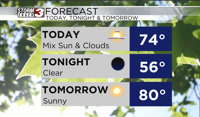


WSIL(Carterville, Ill.)-- This morning, we are tracking temperatures that are unseasonably cool for this time of year. Temperatures for most of us are in the low to mid 50s with mostly clear skies.
As we go through the day, we will see clouds build in and skies are expected to be partly cloudy later this morning and through the afternoon. This will help us stay cool this afternoon with highs today that will be in the mid to upper 70s, and we will see dew points stay in the low 50s; it will once again feel very dry.
Overnight tonight we will see mostly clear skies, which will help us once again cool into the low to mid 50s once again tomorrow morning.
Skies tomorrow will be mostly sunny, and this will help us warm back into the upper 70s and lower 80s for high temperatures. Humidity levels will remain low once again will remain low with dew points in the low 50s.
However, it is still August afterall. For Friday, highs should return to the low 90s with increased humidity. And through the weekend we will see highs in the low to mid 90s, and for next week, highs should stay in the mid 90s thanks to an area of high pressure.
This area of high pressure should keep any substantial chances of rain away. Only an isolated chance of showers is possible Monday and Tuesday.