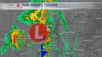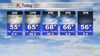


WSIL -- Similar to yesterday, rain will primarily be focused Tuesday during the morning.

By lunchtime, rain will be exiting and it ends up being a really pleasant afternoon. A little sunshine is likely and temperatures will be running into the upper 60s.
Tonight, more showers along with a few rumbles of thunder are likely to return after midnight.

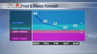
Another wet morning Wednesday as a cold front gradually moves through. In the wake of the front, rain will once again exit, but the afternoon with windier and quite a bit cooler with highs only in the lower 60s.
As a strong system tracks into the Great Lakes region, colder air will filter down the back side of the low and sending temperatures dropping in our area.
Isolated showers are possible Thursday and Friday afternoons and a few snowflakes may even mix in on Friday.

By Saturday, a light FREEZE is possible.