

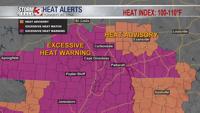


CARTERVILLE, Ill. (WSIL) -- Another day with heat warnings in place, however, a few isolated to scattered showers and storms will be moving through late afternoon.
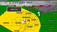
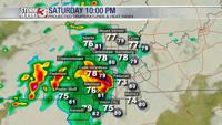
9AM Update: The SPC has given most of the region a Level 2 out of 5 chance of strong to severe storms late this afternoon and evening. The primary risks will be damaging winds and possibly large hail.


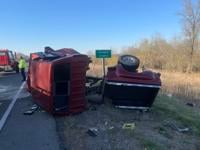
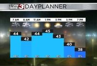
Saturday: Morning lows into the upper 70's and lower 80's.Heat Index into the lower 100's. Afternoon highs into the lower to mid 90's. Another day with heat warnings and advisories set to expire at 7 this evening. Partly cloudy with scattered showers and storms expected into SEMO, moving eastward into IL, KY and TN. A few storms could bring gusty winds in excess of 50mph. As a reminder, we have been fairly dry and trees are not strong after a harsh spring and summer. Tree branches tend to break off easily and whole trees can fall over in stronger winds. Though we aren't expecting severe storms, it doesn't need to be severe to cause damage. Always be weather aware. SW winds 5-10mph with gusts up to 15.
Sunday: Morning lows into the upper 60's to lower 70's with afternoon highs into the upper 70's to lower 80's. Mostly cloudy. Early morning scattered showers and storms will diminish into the afternoon.
Monday: Morning lows into the lower to mid 60's and afternoon highs into the upper 70's and lower 80's. Mostly sunny, a few passing clouds. A nice calm day as a cool NNE wind at 5-10mph.
Looking ahead, temperature highs will be on the cooler side, back into the lower to mid 80's with more sunshine on the way!
Want to stay ahead of your plans? Download the Storm Track 3 App. It's FREE on Google Play and the Apple App Store.