

WSIL -- A record setting morning with low temperatures only falling to around 80º in many locations.
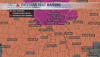
An Excessive Heat Warning is in effect for parts of southern Illinois through Friday afternoon.
Without the benefit of cloud cover, Thursday will be a sweltering day with afternoon temperatures in the upper 90s. A few readings around 100º are possible, mainly from Mt. Vernon to Chester. Humidity will make it feel even hotter with heat indices pushing close to 110º, especially in the Excessive Heat Warning area.
Friday morning will once again be near record breaking with readings in the upper 70s and lower 80s.
Friday afternoon, the humidity may not be quite as high, so the heat index may drop back a few degrees, but actual temperatures will be more likely to top 100º.
The extreme heat and humidity will stick around through Saturday, but a weak cold front will move south Saturday evening.
A few storms are possible Saturday evening ahead of the approaching cold front.
Finally by Sunday, some relief from the heat is expected as highs drop back to the lower 90s.